A powerful ice storm is forecasted to sweep across the Midwest and Mid-Atlantic region by Wednesday, bringing with it a trail of frozen precipitation and potentially hazardous travel conditions. The storm is expected to affect millions of people, with some areas bracing for the worst.
According to the latest forecast models, the states that will be hit hardest by the ice storm include:
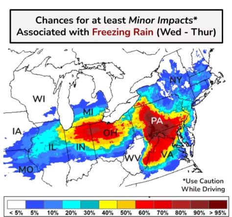
- Illinois: The northern and central parts of the state are expected to receive significant ice accumulation, with totals reaching up to 1/2 inch in some areas.
- Indiana: A large swath of the state is under an ice storm warning, with forecasters predicting up to 1/4 inch of ice accumulation.
- Ohio: The western and central parts of the state are expected to be hit hardest, with ice totals reaching up to 1/2 inch.
- Pennsylvania: The southern and central parts of the state are under an ice storm warning, with forecasters predicting up to 1/4 inch of ice accumulation.
- Maryland: The western and central parts of the state are expected to receive significant ice accumulation, with totals reaching up to 1/4 inch.
The National Weather Service has issued ice storm warnings for many of these areas, warning of hazardous travel conditions and potential power outages. Residents are advised to stay indoors and avoid travel unless absolutely necessary.
The storm is expected to move out of the region by Thursday, but not before leaving a lasting impact on the affected areas. Stay tuned for further updates and follow all instructions from local authorities.


